U.S. DEPARTMENT OF THE INTERIORBUREAU OF LAND MANAGEMENT
Wyoming

updated March 4, 2024
<< Back to Plats & Records

GLO &  BLM Survey Plats & Field Notes

This page contains links to images of the Public Land Survey System for Wyoming. This information consists of images of all available survey plats for the entire state and includes pages of field notes. The plats are organized by county and then by township and range. Additionally, we have posted all of the available images for the Mineral and Homestead Entry surveys.

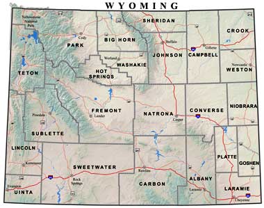
The individual county maps with links to the plats may be viewed by clicking the different counties on the map or by clicking the corresponding text links at the bottom of the page.

If field notes are available for a plat, there will be a label/link on the plat. Click on the label/link to view the field notes. Some of the field note files are quite large and may result in long load times depending on the speed of your internet connection.

map of Wyoming divided into counties link to Park county link to Big Horn county link to Sheridan county link to Campbell county link to Crook county link to Weston county link to Niobrara county link to Converse county link to Johnson county link to Washakie county link to Hot Springs county link to Teton county link to Fremont county link to Natrona county link to Sublette county link to Lincoln county link to Uinta county link to Sweetwater county link to Carbon county link to Albany county link to Platte county link to Goshen county link to Laramie county
Hard copies of plat and field note images are available for a cost of $1.10 per plat or page of notes by contacting BLM Wyoming Cadastral Survey Records at 307-775-6222 or by email.

Albany | Big Horn | Campbell | Carbon | Converse | Crook | Fremont | Goshen | Hot Springs | Johnson | Laramie
Lincoln | Natrona | Niobrara | Park | Platte | Sheridan | Sublette | Sweetwater | Teton | Uinta | Washakie | Weston